The NASA Gallery in Google Earth
Tags: cartography, earth, google, nasa
In 2006, NASA Ames and Google (our next-door neighbor in Mountain View) decided to forge a more formal relationship. One area of collaboration that seemed important from the beginning was making more NASA data accessible via Google’s platforms like Google Maps and Google Earth.
At the time, the Vision Workbench was just beginning to attract some attention as a platform for planetary as well as robotic image processing, and so I was asked to help out in the technical planning of a NASA planetary data collaboration. Eventually it became clear that NASA makes almost all of its data freely available in a reasonably timely manner, turning that data into useful information or “content” was more of a issue. Thus was the Planetary Content Team born.
 I’d never intended to lead the team—that smelled too much like management—but that’s what ended up happening anyway. As a warm-up exercise, and to address the underlying issue that most people aren’t even aware of what data NASA collects in the first place, we decided to build a NASA Featured Content layer in Google Earth.
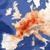
The image above is a screenshot from the Satellite Imagery sub-layer, which I curated from satellite imagery that had been collected an annotated by the NASA Earth Observatory team. This particular overlay illustrates a devastating heat wave that rocked Europe in July of 2003. It shows the land surface temperature anomaly (i.e. the deviation the norm) as measured by the MODIS instrument on board NASA’s Terra satellite. The image on the left is from the Astronaut Photgraphy layer, showcasing some of the unique photographs captured by astronauts on board the International Space Station and the space shuttle.


