COP-15 Forest Monitoring Prototypes
Tags: cop, earth-engine, forests, google
At the United Nations COP-15 international climate change conference in Copenhagen in December, 2009 — eight months after I moved to Google — we took the unusual step of announcing to the world that Google.org was developing a platform for global-scale analysis of satellite imagery called Earth Engine, even while the work was still in its early design stages. We had big dreams, and we knew that achieving them would require us to work closely with the broader scientific, government, and NGO communities, so we had to do it out in the open. You can read all about it on the Official Google Blog and Google.org Blog posts.
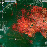
 At first we focused our energies narrowly on the problem of global deforestation monitoring. At COP-15 we demonstrated two early prototype apps that we had built in collaboration with some of the leading scientists in deforestation mapping to better understand exactly what was needed. One was aimed at precise detection of deforestation and forest degradation, using Landsat data and a variation of the CLASlite methodology developed by our partners at the Carnegie Institution for Science. The other was aimed at near-real-time detection of deforestation, using MODIS data and the Sistema de Alerta de Deforestation (SAD) methodology developed by our partners at the Brazilian Amazon watchdog NGO Imazon.


