Global Earth Overlays
Tags: cartography, earth, google, nasa
In the early days of the Vision Workbench I developed some software for the GigaPan panorama image stitcher. It quickly became clear that the problem of building tiled spherical panoramas was essentially identical to the problem of building tiled global maps, and so I made some minor modifications to the software to allow me to build those as well. I built a number of global map overlays for Google Earth during the early planning phases of the NASA Featured Conteent layer, though the only one that we ended up using in the final layer was the city nights at light imagery (at left).
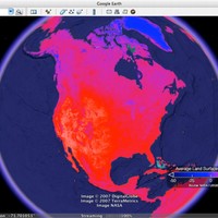
 I released many of the overlays that we didn't end up including in the Featured Content Layer as KML. This included the Land Surface Temperature overlay shown above. At the moment, the folks who were hosting the KML for me appear to have broken it. However, since then I've also built two new global overlays that I'm serving myself: a Sea Surface Temperature overlay, showing month-by-month data for 2006–2008, and an Ocean Chlorophyll Concentration overlay for the same time period. (To see the city lights at night overlay, just look inside the NASA layer inside the Gallery layer in Google Earth. Although if I remember correctly, Google actually rebuilt that overlay themselves before shipping it because my own overlay-generation tools weren't quite polished enough at the time.)


