Google Moon
Tags: cartography, google, moon, nasa
When Google made their original 2D Google Moon site, it was one part serious commemoration of Apollo and one part April Fools joke. After we finished testing the waters with the NASA Gallery layer in Google Earth (then called NASA Featured Content), the Planetary Content Team at Ames turned its attention up to the Moon. Google was getting ready to announce the Google Lunar X PRIZE, and they asked if we could help them freshen Google Moon and make a little more serious in conjunction with the announcement.
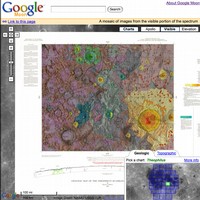
 We upgraded the map with new imagery, including high resolution imagery at the Apollo landing sites, as well as a colorized terrain map mode. We then spent the summer developing tours through each of the Apollo missions, including high-resolution panoramas taken by the astronauts, which we were able to embed in the map using Google’s new StreetView technology. We also added topographical and geological charts, produced in the Apollo era. The image above shows one of the historical maps, and the image at left shows one of the in-situ images we included from Apollo 16. (Fun fact: The chooser user interface element for the historical maps was my first, and hopefully my last, serious JavaScript development effort.)
All of the image processing for the 2007 Google Moon was done using the Vision Workbench, hijacking features that I'd originally developed to support the GigaPan software. This was one of the first serious tests of the Vision Workbench operating at planetary scale, though it paled in comparison to what we would throw at it in 2008.


